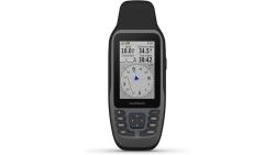
Best GPS Handheld (Marine‑Rated) for Precise Navigation

Introducing Maria, our meticulous planner and talented visual storyteller. She has a knack for discovering those hidden gems, chic boutique spots, and charming little cafes that add a touch of elegance to every journey. With her keen eye for photography and her passion for travel, Maria will transport you to the most enchanting corners of the world, inspiring you to explore new places, one picture-perfect destination at a time.
For precise marine navigation, pick the Garmin GPSMAP 79sc. It pulls full‑color BlueChart g3, stores thousands of waypoints, and features a scratch‑resistant touchscreen that works in rain. If you need floating reliability, the Garmin 86Sci adds InReach and keeps you in contact while on the water. Both units use multiple GNSS constellations for pinpoint accuracy. Keep searching, and you’ll uncover battery tricks, messaging plans, and integration tips and how to sync with your charting apps for seamless routes.
Key Takeaways
- Waterproof and marine‑rated IPX6/IPX8, floats when dropped, ensuring reliable use in harsh sea conditions.
- Multi‑constellation support (GPS, GLONASS, Galileo, Beidou, QZSS) plus SBAS delivers precise real‑time corrections.
- 240×400‑pixel touchscreen or bright, scratch‑resistant LCD with fog‑proof glass for clear visibility in sunlight.
- Roughly 20 h battery life with two AAs (Garmin 79sc/79s) or rechargeable Li‑ion (Uniden), plus optional USB charging.
- Garmin 79sc/86Sci preloaded BlueChart G3 charts, 86Sci adds built‑in InReach/Iridium messaging and weather forecasts.
Garmin GPSMAP 79sc Marine GPS with BlueChart

If you’re a mariner who relies on accurate coastal charts, the Garmin GPSMAP 79sc instantly becomes your go‑to device—thanks to its built‑in BlueChart g3 marine charts. This 2.67 × 6.85 × 1.67‑inch unit weighs 9.9 oz and runs on two AA cells, offering up to 20 hours of GPS mode. It locks onto GPS, GLONASS, Beidou, Galileo, QZSS, and SBAS, giving you up to 10,000 waypoints and 250 routes. The 240 × 400‑pixel touchscreen displays clear images, while a 3‑axis tilt‑compensated compass and barometric altimeter keep you poised. Its IPX6 design survives water, icing, seas, and you can extend power via USB.
Best For: active mariners looking for a lightweight, rugged handheld GPS that delivers detailed coastal charts and multi‑constellation satellite lock.
Pros:
- Integrated BlueChart g3 coastal charts pre‑loaded for quick navigation.
- Multi‑constellation (GPS, GLONASS, Beidou, Galileo, QZSS, SBAS) plus 10 000 waypoints and 250 routes for comprehensive route planning.
- IPX6 waterproof, dust/icing‑resistant design with barometric altimeter and tilt‑compensated compass for reliable operation in harsh marine conditions.
Cons:
- Power limited to two AA batteries (≈20 h GPS mode); extended use relies on external USB backup.
- Small 240 × 400‑pixel display may be harder to read in bright sunlight compared to larger marine displays.
- No built‑in support for external memory cards or advanced connectivity options beyond basic USB.
https://www.amazon.com/dp/B09GX6JSYJ
Garmin GPSMAP 79s Marine GPS Handheld

When you need a lightweight, waterproof GPS that actually floats, the Garmin GPSMAP 79s becomes the go‑to tool for boaters and marine anglers. Its slim 2.67 × 6.85 × 1.67‑inch body weighs under 10 oz, while 2 AA batteries grant up to 20 hours in GPS mode. The bright 240 × 400 screen stays visible even in glare, thanks to scratch‑resistant, fog‑proof glass and sunlight‑readable tech. You’ll control it with buttons, and its 3‑axis tilt‑compensated compass plus barometric altimeter keep you oriented, even in rough seas. With worldwide basemap data and support for GPS, GLONASS, Beidou, Galileo, QZSS, and SBAS, you can chart 10,000 waypoints, 250 routes, and 300 activities.
Best For: a portable, lightweight solution for recreational boaters and marine anglers who need a reliable, floating GPS with robust navigation aids on a limited budget.
Pros:
- Durable, lightweight design that floats and has up to 20 hours of battery life on two AA batteries.
- Weather‑proofed, glare‑resistant 240 × 400 display that remains readable in bright sunlight.
- Multi‑constellation support (GPS, GLONASS, Beidou, Galileo, QZSS, SBAS) with tilt‑compensated compass and barometric altimeter for accurate navigation.
Cons:
- No touchscreen interface; navigation is limited to physical buttons, which can slow input during long missions.
- Relatively small screen resolution and limited data storage (10 000 waypoints, 250 routes, 300 activities).
- Only two AA batteries, which can be inconvenient to replace on extended voyages compared to rechargeable units.
https://www.amazon.com/dp/B09GWCKR59
Garmin GPSMAP 86Sci Floating GPS with Inreach

The Garmin GPSMAP 86Sci is the go‑to handheld for mariners who demand pinpoint navigation right on the water, thanks to its fully floating, water‑resistant design and built‑in InReach satellite messaging.
Its 3‑inch sun‑visible display stays clear in glare, while the compact 1.7 × 2.8 × 7‑inch case and 9.6‑oz weight make it easy to handle. A single Li‑Polymer battery powers it, backed by included mounting accessories. Navigation is boosted by preloaded BlueChart G3 coastal charts, an adjustable GPS filter, and data streaming from compatible chartplotters. The built‑in InReach lets you send two‑way text, trigger an interactive SOS, and receive weather forecasts via satellite, all monitored 24/7.
Best For: mariners on small to medium‑sized vessels who need reliable coastal navigation and 24/7 satellite communication with built‑in SOS capability.
Pros:
- Robust, fully floating, water‑resistant design keeps the unit afloat when dropped.
- Built‑in InReach satellite link provides two‑way messaging, interactive SOS, and optional weather forecasts.
- Preloaded BlueChart G3 coastal charts and GPS filter offer accurate positioning even in rough conditions.
Cons:
- Requires an Iridium subscription for weather alerts and extra messaging beyond free allowances.
- Heavy battery consumption when InReach or GPS use is constant; battery life is limited.
- No standalone Wi‑Fi hotspot; data streaming relies on Bluetooth to other Garmin devices.
https://www.amazon.com/dp/B07XB3HDY9
Garmin GPSMAP 79sc Marine GPS Handheld

Crafted for seasoned mariners, the Garmin GPSMAP 79sc fuses a weather‑proof, floating chassis with multi‑constellation support (GPS, GLONASS, Beidou, Galileo) so you get pinpoint accuracy even when the sky’s a cloud‑shot. Carry it in a pocket or pack; it weighs 8 oz and measures 2.67 × 6.85 × 1.67‑inch. The 3‑inch color LCD, 240 × 400 resolution, sits on scratch‑resistant glass that stays clear in mist. Voice commands on solid buttons keep hands‑free. Preloaded BlueChart g3 charts give navigation aids and shallow zones, holding 10,000 waypoints, 250 routes, 300 fits. Compass and barometer track heading and altitude. Waterproof to IPX6, it delivers 20 h GPS‑runtime, 90‑day limited warranty, availability.
Best For: seasoned mariners who need a lightweight, multi‑constellation handheld GPS with preloaded coastal charts for reliable navigation on all weather waters.
Pros:
- Multi‑constellation support (GPS, GLONASS, Beidou, Galileo) delivers precise positioning even in cloudy conditions.
- BlueChart g3 charts provide built‑in navigation aids and shallow‑water information, with ample memory for waypoints and routes.
- IPX6 waterproof, floating chassis, and barometric altimeter make the unit durable and functional in harsh marine environments.
Cons:
- The 3‑inch LCD can be difficult to read in direct sunlight or low‑light conditions.
- Navigation relies on physical buttons only, lacking a touch interface or gesture controls.
- Battery life is limited to about 20 hours GPS mode, requiring regular recharging on extended excursions.
https://www.amazon.com/dp/B0B5RQRWRJ
Uniden MHS338BT Floating Radio, 6W GPS Bluetooth Submersible

If you need a handheld marine VHF that stays afloat when the water turns to tears, the Uniden MHS338BT gives you IPX8 submersibility, 6‑W transmit power, and a water‑activated strobe that automatically launches a MOB lock‑on—perfect for kayakers, small‑boat operators, and anyone who wants peace of mind while staying light and portable.
Weighing just 10.6 oz and shrunk to 1.5×2.52×4.6 in, it packs a bright orange‑backlit LCD and an 8‑step backlight. Noise‑canceling audio keeps conversations clear, even with a 6‑W output. Bluetooth links to iOS/Android for DSC updates, texting, and app control. Its GPS bookmarks your favorite spots, while auto‑plotting distress calls.
Best For: Kayakers, small‑boat operators, and anyone who needs a lightweight, water‑resistant marine radio with emergency strobe and GPS features.
Pros:
- IPX8 submersible design and automatic water‑activated strobe with MOB lock‑on.
- 6 W transmit power, selectable lower outputs, and noise‑canceling audio for clear communication.
- Built‑in GPS with Favorite Position mode, auto‑plotting distress calls, and Bluetooth connectivity for app control and DSC updates.
Cons:
- Requires a Li‑ion battery that needs periodic charging and may be expensive over time.
- Limited to handheld use; not suited for full‑size VHF setups or dedicated marine clubs.
- App dependencies on iOS/Android may limit functionality if the phone is lost, dead, or out of coverage.
https://www.amazon.com/dp/B0CVCJ97T9
Retevis RM40 Marine Radio with GPS

Adventurous mariners needing precise, hand‑held GPS find the Retevis RM40 aromatic: it delivers sub‑100‑meter accuracy and a handy one‑button DSC that instantly transmits your coordinates. Besides emergency power, its compact 5.5‑inch screen shows real‑time position while you keep an eye on channel 16. The IP67 rating lets you drop it in water, and the LCD flashes red if it tips overboard. You can monitor up to three VHF channels at once, keeping an ear on the traffic channel, your main channel, and a backup. A 1500‑mAh battery runs you for twelve hours on a single charge, and the lightweight 1.81‑lb design lets you carry it in any gear bag. Retevis backs it with a two‑year parts warranty and optional post‑service and a long battery.
Best For: adventurous mariners who need a compact, GPS‑enabled handheld radio for emergency DSC alerts and reliable VHF channel monitoring.
Pros:
- One‑button DSC with accurate sub‑100‑meter GPS positioning for instant distress calls.
- IP67 waterproof rating and red‑flashing LCD enable safe use and over‑board detection.
- Dual‑ and tri‑watch modes allow continuous monitoring of channel 16, main channel, and an additional backup channel.
Cons:
- Battery life limited to 12 hours; requires frequent recharging on long voyages.
- Requires manual MMSI entry for GPS‑based distress messages, adding setup steps.
- 1500 mAh capacity may be insufficient for high‑volume use or when paired with accessories.
https://www.amazon.com/dp/B098NC1QPR
Garmin GPSMAP 86SC Handheld GPS, BlueChart Coastal Charts

The Garmin GPSMAP 86SC pulls ahead for anyone who trades on the water because it never sinks—its floatable housing keeps the unit surfacing even if you drop it into the sea.
You’ll love its 9.6‑ounce, 1.7×2.65×7‑inch shell that stays full of water resistance yet floats if dropped. The 3‑inch, 240×400 color screen is sun‑readable, brightness‑adjustable. Preloaded BlueChart G3 Coastal Maps blend Garmin and Navionics data, while GPS filtering smooths swell. Remote tie‑in supports Autopilot and Fusion Marine. Wi‑Fi, ANT+, Bluetooth upload to Garmin Explore, sync with chartplotters, and pair smartphones. Up to 50 hours, plus lanyard, guide, and 2019 warranty.
Best For: discerning marine navigators who demand a durable, floatable GPS with detailed coastal charts and robust connectivity for safe, efficient voyages.
Pros:
- Floatable design keeps the unit safe even if dropped into water.
- Sun‑readable 3‑inch color display with adjustable brightness; excellent visibility.
- Extensive connectivity: Wi‑Fi, ANT+, Bluetooth, and smartphone pairing.
Cons:
- Slightly heavy for extended hiking or inland use (9.6 oz).
- No internal kill switch; battery still drains if forgotten.
- Limited to BlueChart G3 decks; upgrading charts requires subscription.
https://www.amazon.com/dp/B07XH57DG2
Garmin GPSMAP 79sc Marine Handheld w/ Charts Case

Designed for water‑borne explorers, you’ll appreciate the Garmin GPSMAP 79sc’s robust IPX6 waterproofing, floating chassis, and sunrise‑readable 480 × 272 color display that keeps navigation data visible even on the hottest decks. You’ll rely on its built‑in 3‑axis compass and satellite support (GPS, GLONASS, Beidou, Galileo, QZSS, SBAS) for reliable worldwide tracking. BlueChart g3 maps cover over a gigabyte of chart data. Store up to 10,000 waypoints and 250 routes. The durable Garmin nylon case offers a wide zipper, belt loop, and protects the unit during storage or in‑field use—you can even use it with other Garmin handhelds like the GPSMAP 76S and Garmin.
Best For: adventurous marine pilots and small‑boat enthusiasts who need a rugged, high‑resolution GPS with preloaded coastal charts and a protective travel case.
Pros:
- IPX6 waterproof, floating chassis, and a sun‑readable 480 × 272 color display for clear navigation in bright conditions.
- Supports GPS, GLONASS, Beidou, Galileo, QZSS, and SBAS, ensuring global coverage and reliable positioning.
- Comes with a dedicated Garmin nylon case that protects the unit and is compatible with several other Garmin handhelds.
Cons:
- Limited internal storage (no expandable memory) can constrain large numbers of waypoints or custom maps.
- Lacks Wi‑Fi connectivity for easy data syncing or live re‑routing.
- The battery life, while adequate for most trips, tends to drain faster in extended, high‑usage scenarios.
https://www.amazon.com/dp/B0B82FDHK9
Garmin GPSMAP 65 Button-Operated Multi-Band Handheld 2.6″ Display

When you need precise navigation in rugged terrain, this handheld’s multi‑band GNSS capability and rugged, button‑operated design make it the top pick. It sports a 2.6‑inch color screen that stays readable. With 160 × 240 pixels and a black/bronze palette, icons stay sharp. You get GPS, GLONASS, Galileo, QZSS, IRNSS, and BeiDou for high‑accuracy fixes. TopoActive maps include U.S. public‑land boundaries, so you can plan trails. Bluetooth LE and ANT+ sync with Garmin Explore today, transferring tracks and stats. The unit runs on two AA batteries, weighs 7.7 oz, and comes with a cable, carabiner, guide, all covered by a manufacturer’s warranty.
Best For: experienced hikers and outdoor enthusiasts who need rugged, high‑accuracy navigation in remote areas.
Pros:
- Multi‑band GNSS support (GPS, GLONASS, Galileo, etc.) for precise positioning.
- Durable, button‑operated design ideal for all‑weather and rough terrains.
- Lightweight (7.7 oz.) and runs on inexpensive AA batteries.
Cons:
- No touchscreen—manipulating menus and editing data can be slower.
- Small 2.6‑inch 160 × 240‑pixel screen limits map detail.
- Battery life depends on AA usage; frequent replacements may be needed in prolonged trips.
https://www.amazon.com/dp/B08HR6587B
Garmin Striker Vivid 5cv 5-Inch Fishfinder

If you’re hunting for a pocket‑size sonar that delivers vivid, high‑contrast imaging without breaking the bank, the Garmin Striker Vivid 5cv fits that niche perfectly.
It weighs just 3.8 lb and measures 2.6 × 4.3 × 5 in, making it lightweight enough for handheld use yet sturdy.
The 5‑inch color display shows CHIRP and Vivid ClearVü layers, letting you spot fish and structure instantly.
Built‑in Wi‑Fi links instantly to Garmin Quickdraw Contours, giving you 1‑ft contour resolution for precise navigation.
The unit records waypoints, plans routes, and displays boat speed in real‑time.
6‑hour battery keeps it running all day, and GT20‑TM transducer ships for easy mounting.
Best For: anglers looking for a pocket‑size, vivid‑color sonar with built‑in Wi‑Fi and quick mapping on a budget.
Pros:
- Crystal‑clear 5‑inch Vivid display with CHIRP and ClearVü layers for instant fish & structure spotting
- Built‑in Wi‑Fi and Quickdraw Contours integration deliver 1‑ft contour resolution without extra gear
- Lightweight (3.8 lb) and durable panel‑mount kit with 6‑hour battery keep it handy for day‑long outings
Cons:
- 6‑hour battery life may be short for extended trips or larger vessels
- Full ClearVü imaging requires a separate compatible transducer, not always pre‑installed
- 1‑ft contour mapping is modest compared to higher‑end models with finer resolution and advanced GPS features
https://www.amazon.com/dp/B08LF2CC9P
Simrad Cruise 5–5” GPS Preloaded C‑MAP US Coastal

Coastal boaters who need a reliable, ready‑to‑go map will find the Simrad Cruise 5–5” GPS an ideal fit—thanks to its preloaded U.S. coastal base map that fits right in your hands. The 83‑Hz/200‑Hz CHIRP sonar auto‑traces depth, letting you focus on navigation. Its 5‑inch, sunlight‑visible screen offers full‑screen charts and a split‑screen mode with sonar. Rotary‑dial controls navigate menus, while the keypad eases route creation through C‑MAP Easy Routing. Depth, temperature, speed, position, heading, and battery voltage update simultaneously. Compact 10 × 7.91 × 7.48 in units weigh 3.96 lb, easy on deck. C‑MAP and Navionics compatibility access deeper bathymetry without extra gear for your voyages.
Best For: Small to medium coastal cruisers who want a ready‑to‑go GPS with integrated CHIRP sonar and effortless route planning via C‑MAP.
Pros:
- Ready‑to‑go U.S. coastal base map eliminates extra downloads
- Integrated 83/200 Hz CHIRP sonar auto‑tracks depth for smooth navigation
- Intuitive rotary‑dial and keypad controls make route planning hassle‑free
Cons:
- Limited to U.S. coastal charts; deeper offshore mapping requires Navionics add‑ons
- 5‑inch display may feel small for multi‑user review at sea
- No Wi‑Fi or Bluetooth, so firmware updates are manual
https://www.amazon.com/dp/B07PZL9SB7
Factors to Consider When Choosing a GPS Handheld (Marine‑Rated)
You should first assess how long the device can run between charges, so a long battery life aligns with your expected trips. Then, check that the screen stays readable in bright sunlight and that the unit’s IP rating and splash protection meet your marine conditions. Finally, make sure the handheld supports multiple GNSS constellations and offers precise compass calibration for reliable navigation.
Battery Life Expectations
When you run a marine‑rated GPS handheld, the battery life hinges on a handful of clear‑cut factors. First, most units powered by 2 AA cells clock 10–20 hours of nonstop GPS tracking before needing a recharge. Activating the radio or satellite comms trims that to roughly 8–12 hours. If the device supports solar charging or an external USB port, you can add 2–4 extra hours per day in good light. High temperatures or rapid SD‑card reads can shave playtime by up to 20 %. Finally, models with rechargeable Li‑polymer batteries and power‑saving modes can nearly double backup time compared to standard alkaline‑cell gear. Choosing wisely here keeps you powered throughout your venture. Always review the unit’s spec sheet for precise benchmark figures to fine‑tune your usage plan daily.
Display Clarity Outdoors
Because glare from the sea can erase map lines in a split second, a bright, low‑glare display is essential for marine navigation. You’ll want a sunlit‑readable LCD offering a contrast ratio of at least 12,000:1, so symbols stay sharp even at noon. A 3‑inch panel at 240 × 400 pixels—or higher—gives about 120 ppi, keeping map lines fine at a normal viewing distance. Look for a reflective or low‑power backlight that stays visible in shade without draining the main battery. Touchscreens should feature low‑reflectivity glass; they reduce glare while retaining tactile feedback, helping you select points quickly. Finally, a flicker‑free backlight (≥ 60 Hz) protects your eyes during long daylight runs. Choosing such a display cuts legibility headaches, letting you concentrate on mastering the water instead of the screen.
Waterproof Rating Matters
Once glare is kept in check, the next decisive factor is the device’s ability to endure water. You’ll want at least an IPX6 rating, meaning the unit can stay submerged for minutes without soaking in. Float‑enabled designs keep the GPS afloat if it slides beneath the surface, so you can snag it by a shadow line or spray paint. The housing must pass splash and brief immersion tests; it should shrug off mist, wave splashes, and wet usage. Robust seams and connectors, verified by pressure chamber trials, stop corrosion and keep sensors working after salt‑water or fresh‑water exposure. A 30‑minute, 1‑meter rating gives you plenty of margin on the water while keeping weight and battery life manageable for reliable navigation through unpredictable conditions daily.
Multi‑GNSS Support
Choosing a marine‑rated GPS handheld with multi‑GNSS support gives you instant access to a broader mix of satellite constellations. By tapping into GPS, GLONASS, BeiDou, Galileo, and QZSS, the device can capture hundreds of satellites simultaneously. The larger pool yields quicker locks—even under bridges or in heavy foliage—slashing time to first fix. With more signals, the receiver computes higher‑precision positions, pushing horizontal accuracy down to a few meters no matter how dense the environment. If the unit supports SBAS, it refines vertical data, enabling dependable depth readings for docking and offshore runs. Plus, multi‑GNSS energy efficiency lets the receiver lock fast and idle, stretching battery life during long sailing missions. Therefore, a multi‑GNSS unit offers resilience, accuracy, and endurance—essential for dependable maritime navigation every voyage.
Compass Accuracy Features
With a multi‑GNSS handheld, the next step is ensuring your heading stays true in any sea state. A reliable compass integrates a 3‑axis tilt‑compensated magnetometer, so you get accurate headings even when your vessel rolls or pitches. Regular calibration—spinning 360° and flipping 180°—helps you counter magnetic drift from hull metal and onboard electronics. Units that limit heading error to ±1–2° typically use high‑resolution sensors and on‑board filtering to suppress noisy signals. Shielding and smart software also filter out spikes from docking or transducer interference. Finally, verify your compass against a known true‑north reference, like a gyro‑compass, to confirm error stays within ±3° in all conditions. If your handheld offers tilt‑compensation and software‑based magnetic anomaly detection, you can trust its readings even amid heavy currents.
Chart Pre‑Loaded Options
The first factor to weigh is the scope of the pre‑loaded chart library. You’ll find that many units ship multi‑scale base charts at 1:200,000, depth contours, navigation aid overlays, and hazard markings, giving you full‑coverage route planning in both open‑water and coastal environments. Their internal storage can hold 8 GB to 12 GB, enough for roughly 300 to 400 maps at 1:50,000, covering vast maritime regions. You can swap chart types on the fly—base, reference, offshore—each with detailed shoreline geometry, datum info, and reference line coordinates. Updates arrive via high‑capacity SD cards or over‑the‑air; files range 50 MB to 200 MB and require a 128 GB‑capable card. Dynamic elements like tides, currents, and real‑time buoys also load automatically, ensuring your navigation stays current for safe voyages today.
Portability and Weight
A portable marine GPS handheld that measures roughly 2.7 × 6.8 × 1.7 in lets you keep its 8–10 oz weight on an arm line or a pocket while still feeling sturdy enough for long‑haul use. This compact footprint keeps you light on your belt or kayak, slipping under an armrest with zero bulk. Most units float, so they bob instead of sink, adding a safety cushion that doesn’t balloon the weight. Battery choice matters—two AA cells add 12–16 g each, while a single 300‑mah Li‑polymer cell weighs 15–20 g but keeps power longer, balancing overall kit mass. Strapping or lanyard attachments let you clip the device to your harness, eliminating extra gear and keeping the total wheel‑weight low for extended deployments. Ensuring comfort and longevity on every voyage for any trip.
Frequently Asked Questions
How Long Does the Battery Last on a Single Charge?
Battery lasts roughly 12 to 18 hours, depending on usage and settings. If you keep the backlight dim, use low‑power screen events, and toggle off GPS when not needed, you might squeeze that up to 20 hours. For constant navigation on the water, a 15‑hour rating is typical; high‑power models can push beyond 25 hours with rockets. Remember, batteries degrade, so replace them after four years to maintain performance.
Can I Mount the GPS on a Tripod for Extended Use?
Did you know that 68% of sailors who mount handheld GPS units on tripods report smoother, uninterrupted navigation? You can definitely attach your GPS to a tripod for extended use—most handheld models accept standard 1/4‑inch threaded mounts. Just make sure your mount remains sturdy, keep the screen within eye‑level, and set a secure tripod as the unit can weigh around 0.5‑2 kg. That way, you’ll enjoy steady, precise readings all day.
Does It Support Automatic Chart Updates via Satellite?
Yes, your handheld GPS ships with automatic chart updates delivered via satellite. Each time you go online, the device pulls the latest nautical maps, ensuring you navigate with up-to-date depth contours and buoy positions. You simply enable the auto‑update feature, and the system handles the rest—no manual file transfer required. This keeps your charts current, saves time, and protects you from outdated hazards out on the water and stay safe.
Is the Device Compatible With Wi‑Fi Routers for Data Transfer?
Can you imagine a command center on the water, pulling data straight from your deck’s Wi‑Fi? You’ll be delighted—this handheld really plugs into routers, letting you stream charts, logs, and updates on the fly. With a tiny USB‑Wi‑Fi adapter, you board a vessel and get instant connectivity, no satellite needed. You’ll enjoy efficient, real‑time data transfer, keeping your adventures tightly charted, secure and navigate with confidence always (for safety).
What Is the Water Depth Rating for This Handheld GPS?
The handheld GPS’s water depth rating is 30 meters, so you can confidently deploy it beyond a standard pool depth. You’ll find that its silicone gasket seals everything, keeping moisture out while the unit remains fully powered. When you drop it into rough surf, you’ll notice it stays stable, yet bleeding out data remains straightforward via wireless link. Your navigation experience stays smooth no matter how turbulent the sea today.
Conclusion
You’ve navigated the sea of options and found that the right handheld GPS can transform your voyage into a smooth, chart‑mapped ride. Think of it as your ship’s compass that not only points the way but also sings the currents and tides in real time. By weighing size, battery life, and sensor accuracy, you’ll pick a device that feels like a trusted deckhand—always on time, always true, to chart your course with steadfast precision today.
Handheld Navigation, Maritime GPS, Precise Navigation